Get to Know All About The Nile River Valley Map, Civilization, and Religion
Without a doubt, The Nile River valley is a natural miracle that sustains every Egyptian’s life. This article’s goal is to provide readers with comprehensive information about the impact and history of the Nile River. Expert tour guides, and tour operators familiar with all aspects of the Nile River have collaborated on this article.
As early as the dawn of civilization, thousands of years ago. The Nile river served as the primary source of irrigation that turned the desert into fertile farmland. There is no sign of that changing any time soon, so the river is used for transportation and trade and as a source of irrigation.
In Egypt, the Nile River serves as a unifying symbol, drawing together residents of the river valley communities to enjoy the water and the remnants of long-gone civilizations.

The Map of the Nile River Valley in Ancient Egypt
Learn About Ancient Egypt Nile River Valley…
Ancient Egypt was located in northeastern Africa and divided into four distinct geographical zones: the Delta, the Western Desert, the Eastern Desert, and the Nile Valley. Each of these zones had its own natural environment as well as a distinct role within the Egyptian state.
Cities could only thrive in the Nile Delta, Nile valley, or desert oases where people had access to water, land, and other essential resources.
The ancient Egyptians, who were always keen observers of nature, frequently associated the Nile Valley with life and abundance, while the neighboring deserts were associated with death and chaos. In Ancient Egypt, Kemet, or “black land,” refers to the Nile Valley‘s rich, fertile land.

The Nile River Valley Civilization in Ancient Egypt
How did the geography of the Nile River Valley lead to the growth of civilization there?
In fact, Egyptian civilization grew along the River in large part because the river’s annual flooding provided consistent, rich soil for crop cultivation. The importance of the region’s agricultural production and economic resources was demonstrated by repeated struggles for political control of Egypt.
The king was regarded by the Egyptians as the unifier of the “Two Lands.” One of the king’s primary responsibilities was to keep Upper and Lower Egypt united; the Egyptians expressed this visually through the sema-tawy motif. Two Nile gods are depicted here, symbolically uniting the lands of Upper and Lower Egypt, each in the form of their respective plant, the papyrus for Lower Egypt and the lotus for Upper Egypt.
Ancient Egyptian Calendar
In addition, The Egyptians built their calendar around the annual cycle of the Nile. It includes three main seasons: Akhet, the period of Nile inundation, Peret, the growing season, and Shemu, the harvest season.
The Egyptians created Nilometers to measure and track the height of the annual inundation; they used the recorded readings from these Nilometers in the same way that modern farmers use almanacs. Elephantine Island in Aswan has a particularly well-preserved example.

The Social Structure of the Nile River Valley And Nile River Valley Religion
Society Structure
Basically, Egyptian society was in the shape of a pyramid. The gods, such as Ra, Osiris, and Isis, were at the top. The Egyptians believed that the gods ruled over the universe. As a result, it is critical to keep them happy. They could cause the Nile to overflow, famine, or even death.
The Religion
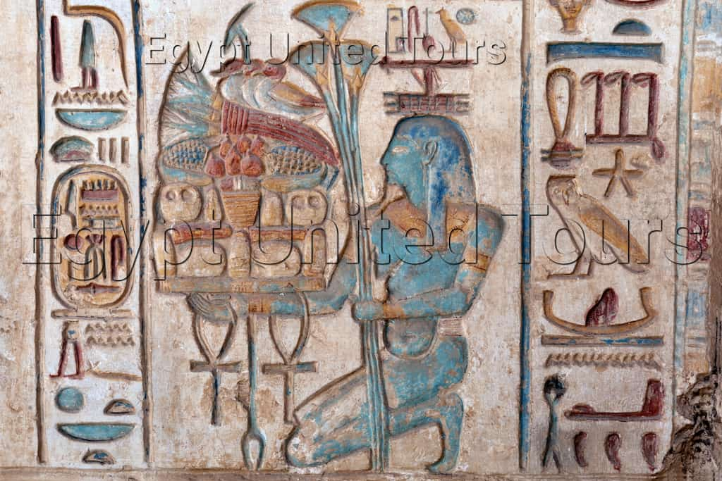
Hapi is the Nile River’s god and the source of life for all the people, animals, and plants that surround it in ancient Egyptian mythology. Because of their excessive obsession with the power of the Nile River and its blessings, they gave him a prominent role in their stories.
Many ancient prayers extol Hapi, the Nile god, as the giver of all life and tranquillity, the destroyer of darkness, the irrigator of Ra’s fields, and the producer of grain.
Where is the Nile River Valley Location?
In fact, The Nile river valley on the map, in fact, describes how it flows and its origins. It has two major tributaries on the river map: the White Nile and the Blue Nile. These two rivers meet just north of Khartoum (the capital of Sudan).
The White Nile is the Nile’s headwaters and primary waterway. The White Nile originates in central Africa’s Great Lakes region, with the most distant source unknown until now but thought to be in Rwanda or Burundi.

The Blue Nile flows from Lake Tana in Ethiopia. A massive delta connects the Nile to the Mediterranean Sea.
Experience the unmissable visit to Luxor and Aswan to explore Ancient Egyptian Life, Temples, and breathtaking view with our Nile Cruises Packages to Luxor and Aswan.